Getting everyone on the same page about littoral compliance.
Litora measures littoral vegetation from aerial drone imagery, giving your
community, your pond manager, and your county one clear, consistent number to work from.
Litora is in active development. We are currently sharing private demos with
a small group of Florida communities, pond management companies, and certifiers.
Why it matters
Right now, littoral coverage is estimated by eye from the shoreline.
Litora measures it directly from aerial imagery, so the result is consistent and repeatable.
That gives everyone involved, from the community to the county, one shared number
to work from.
What Litora does
Measure coverage. Identify species. Track it over time.
A focused tool for pond littoral compliance: measure how much of the pond is
covered, identify which species are growing, and turn it into a clear record you can compare year over year.
Measure coverage
Color and texture analysis reads living littoral vegetation from aerial imagery and
reports it as a percentage of the pond, ignoring reflections, glint, and open water.
Objective and repeatable
Identify species
Litora also identifies the plant species present and reports them by percentage, so you can see
the native and invasive makeup against the requirement, not just the total coverage.
Native vs invasive
Document clearly
A clean, timestamped report showing the measured coverage and species against the requirement,
ready to share with everyone involved.
A clear, shareable record
Track year over year
Re-fly the same pond and compare coverage and species over time. Litora measures and documents;
treatment decisions stay with your pond management partner.
We observe, we do not prescribe
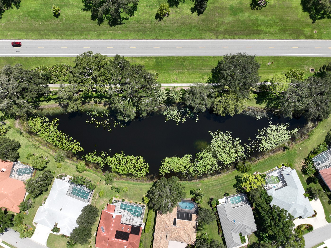
A real Litora report
Watch the data lift out of the imagery.
This is an actual Litora report for a Sarasota County pond. Watch the
littoral vegetation Litora measured paint back in over the raw drone image.
LITORA · by Duplain Aerials
JUNE 4, 2026
Pond 4-3
Littoral Zone Compliance Report · Sarasota County
COMPLIANT
Loading imagery
0.0%littoral coverage
Pond vegetation27.1%of pond area
Requirement≥19.5%Sarasota County
✓ Passneed ≥19.5%
An actual report, generated in Litora. The live app runs at full drone resolution.
Who it's for
Built for everyone at the table.
Pond compliance involves a lot of people. Litora gives all of them one
shared, trusted measurement to work from, so nobody is guessing and nobody is taking another
person's word for it.
Community & HOA boardsKnow exactly where your ponds stand.
See the real littoral coverage on every pond, plan ahead with confidence, and come
to your pond manager and county with a clear measurement instead of an estimate.
Pond & lake management companiesPlan treatments against a real number.
Work from an accurate measurement, not a visual guess. Show the community and the
county exactly what you intend to do, and confirm where a pond stands before and after.
Certifiers & engineersA consistent measurement to build on.
The same repeatable method every time, with the actual imagery behind every number,
so the record holds together and is easy to compare year to year.
Counties & regulatorsA clearer read than a visual estimate.
A more accurate, standardized measurement than an eyeball estimate, with the imagery
to back it, so reviews start from something everyone can see.
One shared report. One number. Everyone on the same page.
Built by Duplain Aerials
Real flights. Real ponds. A measurement everyone can trust.
Litora is the measurement platform behind Duplain Aerials, a Part 107 drone
operation serving Florida communities. It was built against real pond imagery, not a lab dataset.
Aerial-grade imagery
Licensed Part 107 drone flights, stitched into one high-resolution view of the whole pond.
A repeatable method
The same analysis every time, so reports from different years are directly comparable.
Refined on real Florida ponds
Built and tuned on live community pond work, not in a vacuum.
Questions
Common questions.
How is this different from how compliance is measured now?
Today, littoral coverage is estimated by eye from the bank. Litora measures the
actual vegetation from aerial imagery, so the number is consistent, repeatable, and anyone can
see how it was reached.
Is this an official certification?
No. Litora is a measurement and documentation tool. It gives you an accurate, shareable
read to bring to your pond manager and county. Treatment and compliance decisions stay with them.
Who flies the pond?
Duplain Aerials handles the licensed Part 107 drone flight, then Litora turns that imagery
into the report. The analysis happens at the desk, not in the field, so you do not fly or process
anything yourself.
How often should a pond be measured?
Most communities do it once a year. Because the method is the same every time, you can
compare year to year and see how a pond changes.
Does Litora decide what to remove or treat?
No. Litora measures and documents the condition, including coverage and any overage.
What to plant, remove, or treat stays with your pond management partner and the county.
Request a demo
See Litora on your ponds.
We are lining up demos with a small number of Florida communities, pond
management companies, and certifiers. Tell us what you manage and we will be in touch. No spam, no list.